Trending...
- $1B Target by 2027 Amid eSIM, Global Roaming Expansion; $57.6M Q1 Revenue and Market Uplisting, Advancing Toward IQSTEL, Inc. (Stock Symbol: IQST)
- LIB TH-50/TH-80 Benchtop Environmental Chamber Drives Global Demand
- Marc Soucy's Newest Music Series Approaches Its One Year Mark
GATINEAU, Quebec - WisconsinEagle -- CartoVista, a leading provider of web mapping solutions is excited to announce CartoVista Cloud 8.1. This latest release showcases significant enhancements to the platform's GIS connectivity and flexibility, empowering GIS and business professionals to create better interactive story map presentations online.
"CartoVista is a unique interactive mapping solution. We deployed our information with extraordinary efficiency and speed. CartoVista allowed us to create more than 8 complete interactive atlases, from socio-demographic and economic statistics to social development, mobility, environment and waste management in a simple way." - Bruno Labontė, Geomatics and Information Technology Coordinator, Communauté métropolitaine de Québec.
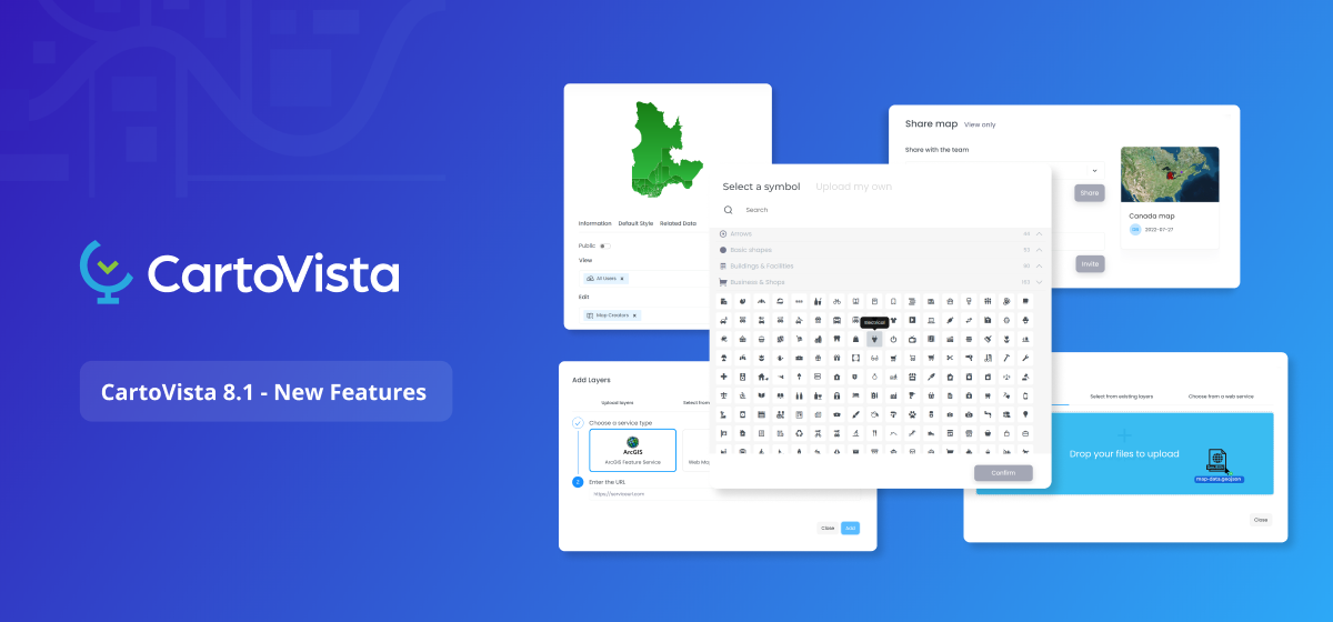
CartoVista Cloud 8.1 introduces a range of new features designed to streamline workflows and elevate the mapping experience. Key highlights of this release include:
More on Wisconsin Eagle
To learn more about CartoVista and its latest release and trial the software, please visit https://cartovista.com/platform/.
"CartoVista is a unique interactive mapping solution. We deployed our information with extraordinary efficiency and speed. CartoVista allowed us to create more than 8 complete interactive atlases, from socio-demographic and economic statistics to social development, mobility, environment and waste management in a simple way." - Bruno Labontė, Geomatics and Information Technology Coordinator, Communauté métropolitaine de Québec.
CartoVista Cloud 8.1 introduces a range of new features designed to streamline workflows and elevate the mapping experience. Key highlights of this release include:
- ESRI ArcGIS / AGOL Integration: Seamless integration with ESRI's ArcGIS enables users to connect map layers and data galleries using ArcGIS Feature Services. This integration simplifies the data integration process by allowing users to create interactive layers in their CartoVista story maps with a simple URL entry for the layer feature service.
- Enhanced Map Symbol Functionality: With over 1800 map symbols, users have a vast library to choose from. Users can also add and customize their own symbols from SVG and various image formats (PNG, JPG, GIF), ensuring accurate representation of their point data. Further, new keyword search functionality saves time by facilitating the discovery of appropriate symbols.
- Simplified Map Sharing and Permission Management. Users can now easily adjust sharing permissions with confidence, thanks to new user-friendly display messages that ensure awareness of the consequences of their actions. Furthermore, personalized email notifications featuring map thumbnails make it effortless to share maps with colleagues or the public.
- Access to OGC Web Map Tile Service (WMTS): CartoVista 8.1 further simplifies the data integration process by providing access to OGC Web Map Tile Service (WMTS). Users can save time and effort associated with adding large WMTS data layers in the cloud by simply entering the service URL.
- Drag and Drop GeoJSON Data: Adding a new layer to the map from a GeoJSON file is now quick and hassle-free with CartoVista 8.1's intuitive drag and drop functionality.
More on Wisconsin Eagle
- Tee Up for Chosen: Charity Golf Outing to Support Foster, Adoptive & Kinship Families
- 150% Increase in Fiscal Q2 Sales vs Previous Year to $750,000; Continuous Record Quarters & Profitability for Homebuilding Product: Innovative Designs
- Use Dogecoin (DOGE) to mine Bitcoin (BTC) and earn passive income at home
- European Tech Startup RoarFun discovers a gap in the U.S. market with a branded racing simulator rental at Atlanta's MRO Americas Aviation Convention
- Degrees of Justice: Attorney Frank Walker Charts the Future of Criminal Justice with Ph.D Degree
To learn more about CartoVista and its latest release and trial the software, please visit https://cartovista.com/platform/.
Source: CartoVista
Filed Under: Business, Government
0 Comments
Latest on Wisconsin Eagle
- Sumis Partners Launches, Uniting Industry Leaders to Redefine Life Sciences Consulting
- DivX Launches Ultimate Guide to Free MP4 Playback
- Chosen Inc. of Wisconsin Announces Inaugural Sept. 24 Golf Outing
- Boston Industrial Solutions, Inc. introduces an advanced solvent for LSR silicone
- U.S. Lawmakers Propose New $250 Fee for Green Card Lottery Applicants
- NBA Legend Jeremy Lin, Benny Luo and Sy Huq Team Up to Executive Produce Powerful New Short Film "Ayo, Check Up!"
- 70% of Business Owners Are Winging It – Book Aims to End the Chaos and Make Marketing Fun Again
- Skyline Introduces the Industry's First High-Quality Portable Counter with LED Edge Lighting
- Men's Health Network Urges Memphis Community to Attend 2025 Men's Health Month Summit
- L2 Aviation Honored with James A. Wuenker Growth Award by REDI Cincinnati
- APA Faces Outrage: Child Deaths and a $329 Billion Mental Health Failure
- Class of 2025 - NYC Basketball Hall of Fame
- The Smart Way to Run Your Flooring Business: Comp-U-Floor Delivers Game-Changing Flooring Industry Software
- Bluumly Chosen as Finalist for the 2025 MIT Sloan CIO Symposium's Innovation Showcase
- Live Good Relaunches "Be The Generation" Initiative to Empower Student Leadership Amid Cuts to Public Health and Education
- Host Your Next Retreat in Costa Rica: Tamarindo Bay Boutique Hotel & Studios Offers the Ideal Setting in Playa Tamarindo, Costa Rica
- Koplon Implant & Family Dentistry Receives National Recognition as One of the Best Dental Implant Practices in the U.S
- San Antonio Buyer Secures 2.375% Mortgage in 2025-Broker Reveals the Mistake Costing Buyers Thousands
- Heritage at South Brunswick Grand Opening Success!
- $1B Target by 2027 Amid eSIM, Global Roaming Expansion; $57.6M Q1 Revenue and Market Uplisting, Advancing Toward IQSTEL, Inc. (Stock Symbol: IQST)